Tuesday, May 30, 2023

Part of a Roman rotary quern?


Not me, you fool! - I mean the broken-in-half Roman rotary-quern. 

Such a quern works as described in this video. When complete, this stone would have had a hole in the top, and a hole in the side (you can see two-thirds of it at the point of breaking) which would have had a horizontal stubby stick inserted. 

Wheat, barley or rye would have been dribbled down the hole while turning this upper-part of the quern on a flat stone base, probably incised with lines to collect and channel the resulting flour. The flour came out all around the edges and was collected onto something like a leather hide underneath the quern, a flat board, or a larger flat stone. 

It was a very slow method of grinding, taking (I believe) more than an hour of hard work to grind enough grain for a loaf. 

This object we inherited from an ancient relative, who lived in West Northumberland in the vicinity of many Roman Ruins - which is why we believe it is Roman. 

But to be honest, I can't identify it with any degree of confidence. You might be able to see that it is fluted with vertical hollows - and I haven't been able to find any other similar-looking quern online in order to try and get a better date. 

Anyway, it's very old, and an impressive chunk of masonry. 


Saturday, August 31, 2019

Long Meg and her Daughters


Long Meg and her Daughters is a surprisingly large Neolithic stone circle in Cumberland, near Penrith; which we visited recently. It was an enjoyable experience - as others have found.  The site originally will have had a very broad 360 degree view to distant hills and horizons; and it slopes slightly toward the Pennines, as if the shape was intended to be visible from the flanks of Cross Fell and thereabouts.

It has several special features - first is Long Meg herself - a red sandstone pillar with 'rock art' concentric circular symbols still visible on one face (archaeology suggests there was originally another similar pillar, making an 'entrance); and the main circle of her daughters - made of grey stones; through which a small road goes.

Of the circles I have visited, it is most like Avebury, although smaller. The Daughter stones vary a lot in size - reinforcing my idea that each stone probably symbolically represented (was 'like') an individual person (or deity). Also the Daughters are spread-out, with no impression of ever having been contiguous. This differs from other Cumbrian circles such as Swinside and Castlerigg, which look as if originally the stones were placed close together, contiguously, to make an enclosing-excluding 'wall'.

A similarity with Castlerigg is that there is an area that looks as if there are extra stones that perhaps originally made a 'sanctuary' or 'chapel' jutting-in from the perimeter. 

From the fact that so many survived 4000 years plus; the British Isles must once have been covered in these and similar structures in the late Neothlithic-Bronze Age - I find it quite a remarkable thing to imagine moving through such a 'ritual landscape'. The stone circles are associated with other features such as pathways, parallel ditches (cursus), and various types of burial (some long barrows predate the stone circles).


The circles themselves seem like sky temples to me. I am impressed by the fact they don't have anything at the centre - just like the sky; but I don't believe that most of the stone circles have significant astronomical alignments. They are just not sufficiently regular geometric structures - the stones are very rugged and various in size and shape - and most are not even true circles. (e.g. LM and her Ds is flattened on one side).

My current guess is that the circles were dedicated to the sky god/s and stones were added to after the deaths of significant persons - or perhaps to represent gods. But they were clearly very important indeed - the sheer size of some stones is evidence of the work required to make them. The positions are distinctive and rare. They are part of complexly-shaped landscapes.

Probably, this was a literate society (the 'rock art' being the remnants of their 'writing'); and the number of these temples suggests a large pantheon, or in some way different functions of different temples (as with the much better documented and contemporary Egyptian religion).

I get the impression of life lived in this context; of life being a movement-through these sacred landscapes - perhaps following narratives of divine history; people continually reliving the primal stories of their gods.


Friday, June 14, 2019

The Duddo Stone Circle


Visiting the Duddo stones was a pilgrimage - since they are in the far north of the county of Northumberland, and off the beaten track. Yet the pilgrimage was always intended; since these are among the favourite megaliths of England, among the few that have experienced them.

As it happens, we had pretty terrible weather - with, as can be seen from my photos (and my wife's - that's me posing in the bottom picture), driving wind and rain. A pilgrimage is not meant to be easy - yet the famous view of the Cheviot Hills was completely obscured, which was a negative.

On the other hand, as is usual with megalithic circles; the position, on a ridge as we approached from below, was striking and clearly significant - even with poor visibility.

And the stones themselves are very impressive - after some 4000-plus years, there are only five remaining, and and the sandstone blocks are deeply grooved by erosion into tooth-like shapes.

Note: Looking at the individual stones, photos three, four, five; I notice now (but didn't at the time) that each stone is set-into a mini-'crop circle' of swirled grass. Strange...

Tuesday, April 2, 2019

Melrose and the Eildon Hills


Melrose, with the adjacent Eildon Hills, is an ancient settlement in the Scottish Borders; previously a part of the Kingdom of Northumbria. The town grew around the abbey (rems of above; ruined by the Scottish Reformation - Robert the Bruce's heart was buried here). But its earliest town constituted about 600 huts of the Iron Age/ Celtic/ Cymric people on top of North Eildon - one of the three famous peaks that dominate this area:


The Eildon Hills are famous from association with wizards, of different types. Michael Scott was a medieval professor, mathematician and magician - who ordered what was originally a single peak to be cleft into three by some demons.

Not long afterwards the prophet and poet Thomas the Rhymer was lying on the banks of this hill, and met the Queen of Elfland - he became her lover, and spent seven years in Faery before revising mortal lands (nearby Ercildoune) with the gift of prophecy. He later returned to Elfland, led by a white hart and hind...

This is told by another 'wizard' who resided here - Sir Walter Scott - in his Minstrelsy of the Scottish Border.

Coming-down off North Eildon, can be seen the conical peak of Middle Eildon (the highest) with West Eildon to the left.

The other wizard was that most famous of all - Merlin. This is one of the places where Merlin guards  King Arthur and his knight under the earth - in an enchanted sleep with horses all ready to rescue the nation at need. Such was attested by a visiting Carlisle farmer who supplied one of the horses, and was led into the side of one of the hills by a wizardish-looking old man: I think the cleft in North Eildon - pictured below - was probably the place of the magically hidden doorway. 


Wednesday, March 6, 2019

The Celtic defended settlement on Slate Hill, Bolam

Our expedition last weekend was to Slate Hill, and its not (yet?) excavated, but almost certainly early Iron Age ('Celtic' - probably about 700-500 BC) mini-
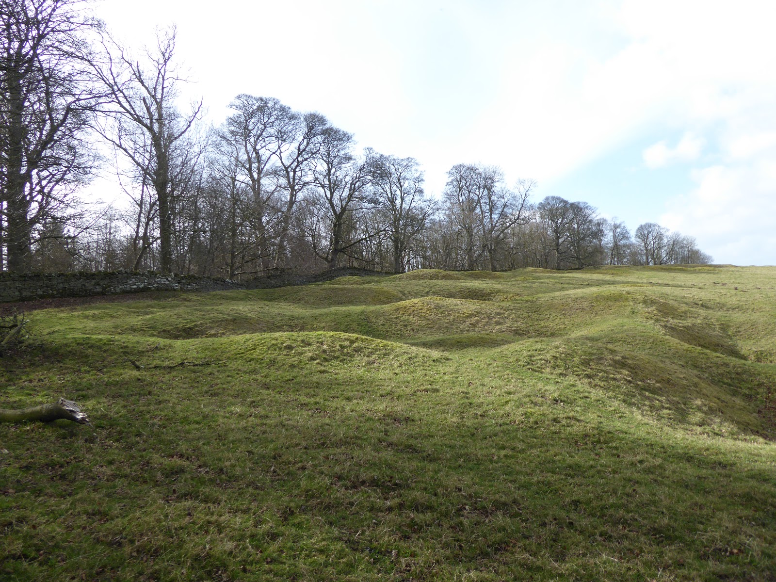
hillfort to the north of Bolam Lake. It is the roughly semicircular structure made by little black triangles and labelled 'settlement':


There are remains of an impressive four concentric rings of mounds surrounding the settlement - which are presumed to have been topped by walls and a palisade. To the south there is a steep cliff, now wooded. This implies a significant need for defence, and therefore a significantly violent, warring kind of society.

Modern methods of excavation often reveal that these Celtic forts (at least in the South of England) were built on top of Neolithic-Bronze Age 'temples'. In Neolithic-Bronze Age times, such hilltops seem to have been non-residential places which people attended for feats and other (presumed) rituals. These usually had a single circular mound and ditch - and some had stone circles. Whether something of the sort lies beneath Slate Hill is not known; probably not.

When the large scale, peaceful Neolithic-Bronze Age society broke down into warring tribes, these temples were sometimes occupied and defended by further ditched, and walls and palisades. Some of these pre-Roman forts were again and further fortified in post-Roman times against the invading Anglo-Saxons. This was the case of the much larger South Cadbury ('Camelot') in Somerset.

However, Slate Hill is a much smaller affair - perhaps the residence of an extended family rather than a clan. 

An artist's impression of the place:


The Ancient British Celts seemingly liked to live in round houses; and even during the Roman occupation this preference continues. This in turn suggests something more than either fashion or functionality - that the roundness of the houses, the internal layout (hearth at the centre) probably has some fundamental  religious significance.

It has been suggested that - in this warring, small-scale society - and after the Neolithic-Bronze age 'megalithic;' structures had fallen into disuse (presumably defended from general access, and/or too dangerous to visit); the household may have become the centre of religious practice.  

Inside the enclosure there are many lumps and bumps of grassy earth, but nothing we could identify. The whole area, including inside the enclosure, has multiple conical depressions about 20 feet across - these are the remains of slate mines from the past few hundred years (which gave the hill its name). No doubt these will have destroyed a fair bit of the Iron Age structure, but they have certainly made for an appealingly intricate landscape.


The site commands a delightful view to the North - including a further, larger, nearby defended enclosure which we hope to visit soon. This is indeed part of a larger multi-site landscape of ancient features, including three other hillforts.
 

Monday, February 25, 2019

Stumbling upon a 'new' cup-marked stone at Shaftoe Crags

We often walk at Shaftoe Crags, in Northumberland - and this time we went in search of Hallion's Rock - which is a recorded example of 'Rock Art'.

It was a beautiful, mild late-February day, with high wispy clouds. Not difficult to imagine the ancient past - and nobody around except some distant boulder-climbers.

Unfortunately, I had forgotten to bring the Hallion Stone description with me - and all I could remember from an online source was that it was near the Jubilee Stone, probably in a North Easterly direction.


We searched nearby, and could not find anything - my recollection was that the stone had cups and channels - but not much in the way of rings around the cups. Drawing a blank, we continued northwards from the Jubilee Stone along the to of the low (15 feet) broken scarp face. After about 100 yards we found a stone sticking out from the scarp face and covered with cup marks and some channels.


But on examining the map later, it is clear that is is Not Hallion's Rock - which is down on the plain in front of the scarp. Indeed, this extensively cup marked rock doesn't seem to be noted in any of the sources I have found - so, here are some more photos.


We sat just above the rock and drank some water while looking out across the plain into the haze, and - as usual - puzzling over this strange phenomenon of cup marked rocks. Given the effect of four thousand years of erosion on this soft sandstone, it is hard to imagine what the original carving were like. And the abundance of this feature even now suggests that there must have been hundreds-fold more examples in the past - indeed, it is possible that most large rocks in suitable places were thus marked.

Was it 'art'? I doubt it. I assume the markings had spiritual significance, and also represented something - landscape features, or perhaps a kind of writing. Although what remains on this rock is simple - some other rocks in the area are very elaborate, and plausibly carried detailed symbolic meaning. Perhaps (given the use of underground burial chambers, and open-air stone circles) this was part of their earth-sky religion?

And it must have taken a lot of work to make even these hollows, 'pecking' them away with a harder stone. A serious business, one way or another.

Some elaborate marking at Roughting Linn, Northumberland


Part of a Roman rotary quern?

  Not me, you fool! - I mean the broken-in-half Roman rotary-quern.  Such a quern works as described in this video . When complete, this sto...